Harnessing topobathymetric Lidar for climate resilience
Survey supports hydraulic modelling and flood planning
A topobathymetric Lidar survey was conducted to support flood preparedness in Canada. Which techniques achieved exceptional precision, and what were the logistical challenges? Find out more in this article.
As a result of major recent flooding events in Canada, the Communauté Métropolitaine de Québec (Quebec Metropolitan Community/CMQ) recognized the need for highly accurate surveys of its watercourses to inform flood preparedness and civil security. This article explores the techniques used to achieve an exceptional degree of precision in the topobathymetric Lidar survey conducted by NV5 Geospatial, as well as the logistical challenges that can impact the success of similar projects.
Over the last decade, several of Canada’s provinces and major cities have experienced major flooding events, including Alberta (2013), Vancouver (2021) and Quebec (2017). These devastating weather events were global news stories, demonstrating the potential threat posed by Canada’s extensive coastlines and watercourses. In Quebec, the 2017 floods caused significant damage and disruption, leading Quebec’s Ministry of Public Safety to develop an action plan for civil security and flood preparedness.
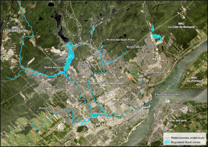
While Quebec City itself was not impacted by the 2017 flooding, CMQ understood the need to prepare for potential flooding events in the future. Home to more than 500,000 inhabitants, Quebec City sits on the bank of the Saint Lawrence River and is dotted by a network of smaller bodies of water. Rising water levels could prove disastrous for the city, threatening both physical and economic security. CMQ needed highly accurate maps and models of its watercourses in order to prepare for the consequences of various flooding scenarios.
The topobathymetric Lidar method
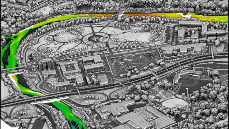
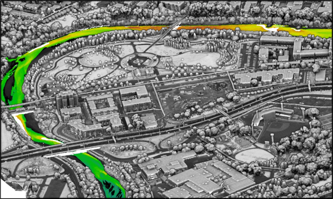
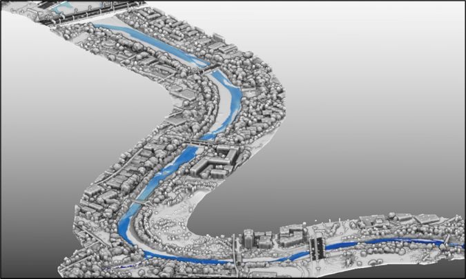
Topobathymetric Lidar was identified as the appropriate method for accurately mapping and modelling the watercourses in Quebec. This method of remote sensing simultaneously measures and records three separate surfaces: water, land and submerged land. A combination of airborne laser-based sensors are used to collect data on the disparate surfaces; a near-infrared laser maps land and the surface of the water, and a visible green laser penetrates the water to map the submerged land.
CMQ commissioned its first topobathymetric Lidar surveys in 2019. The results led the organization to commission a wider survey in autumn 2022. NV5 Geospatial (NV5) was contracted to collect topobathymetric Lidar data over eight additional watercourses, amounting to a total area of 7,000 acres (2,833 hectares). The largest component of the survey was the Saint-Charles River, with the survey including 2,000 acres (809 hectares) of land along the banks of the river. The city planned to use the expanded datasets to inform extensive hydraulic modelling, which would allow the local government and businesses to prepare for flooding events more effectively.
Situational challenges
Topobathymetric Lidar surveys are heavily dependent on suitable weather conditions. Not only can inclement weather impact both airborne data acquisition and ground preparations, but it can also affect tide conditions. Water surfaces must be sufficiently calm during the survey to ensure precise, usable data.
Airborne Lidar surveys can also be hampered by other factors, including airspace restrictions and private property access. A successful topobathymetric Lidar survey requires extensive preparation to work efficiently and complete the assignment within the allotted time frame. CMQ expected the work to be conducted during typically low-flow conditions. Any significant delays in the data acquisition process could have resulted in NV5 missing the window of opportunity before the onset of winter and increased precipitation.
Preparation, collaboration and communication
Both CMQ and NV5 understood that detailed preparation and seamless communication would be necessary to achieve the desired results of the survey. Building off the previous experience with topobathymetric Lidar, CMQ conducted the pre-flight ground surveys and provided detailed recommendations to the NV5 survey team. The two teams also worked to identify structures which control water flow along the rivers in the survey area, coordinating with the responsible institutions to maintain still waters whenever possible.
Recognizing the need for consistent performance within a limited window of time, CMQ wanted to review each day’s data as soon as possible following completion of the survey. NV5 delivered the collected data in near-real time using its client portal, INSITE, and the two teams worked together to determine which surveys were successful and which required additional flights. The NV5 survey team conducted all survey flights in a Piper Navajo aircraft, using a Leica Chiroptera 4X shallow-channel topobathymetric Lidar sensor and a HawkEye 4X deep-channel bathymetric Lidar sensor to collect the necessary measurements.
Novel solution to changing weather
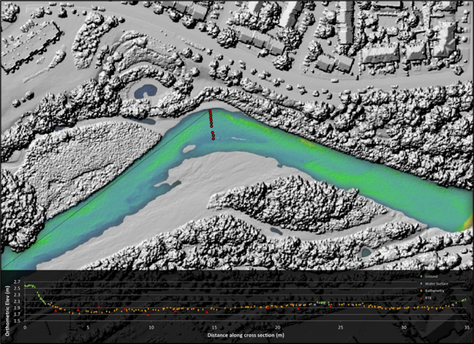
In a typical topobathymetric Lidar survey, the team will identify which flights produced the best data for each specific area and will then conduct manual and automated processing. The process is akin to capturing several separate images, editing the images and then stitching them together for a complete image. However, the ever-changing weather of Quebec City led the NV5 team to take a novel approach to this process. Because of the unpredictable shifts in weather during each individual flight, the data processing team realized that individual flights contained both exceptional survey data and data that had been compromised by sudden rainstorms. Therefore, the NV5 team integrated the best results from each flight into a single, highly precise composite point cloud. As a result, CMQ could be sure that the received point cloud delivered the absolute best possible results. These efforts will pay off for years in the city’s future hydraulic modelling and civic planning efforts.
Valuable set of best practices
By combining CMQ's experience with NV5’s expertise, the two parties achieved a groundbreaking result: the first complete bathymetric digital model in Quebec City. So which lessons can be learned from this project? Firstly, it confirmed the importance of detailed, careful planning and of taking every possible step to minimize water flow and potential weather disruptions. Moreover, the project underlined the value of committing to a longer period for data acquisition; the NV5 survey team spent nearly one month in the Quebec City area, ensuring that the acquisition process could take place without pressure or stress. Lastly, this topobathymetric Lidar project demonstrated an effective approach to post-acquisition data processing. By providing raw data in real time, NV5 allowed CMQ to confirm satisfaction with the acquisition process and participate in decisions on where and when to conduct additional survey flights.
The NV5 team’s innovative approach to point cloud mapping also showcased the performance improvements that are possible when going beyond standard practices in order to deliver the optimal result. The planning, acquisition and processing phases of this project could serve as a valuable set of best practices for future topobathymetric Lidar surveys in North America and beyond, helping other cities with major watercourses to face the threats of climate change and rising water levels.
Value staying current with geomatics?
Stay on the map with our expertly curated newsletters.
We provide educational insights, industry updates, and inspiring stories to help you learn, grow, and reach your full potential in your field. Don't miss out - subscribe today and ensure you're always informed, educated, and inspired.
Choose your newsletter(s)


